Global Site
Displaying present location in the site.
Rapid Disaster Situational Awareness Through the Integration of Satellite Image Analysis and LLM
Vol.18 No.1 May 2025 Special Issue on Green Transformation — The NEC Group’s Environmental InitiativesIn response to the increasing frequency of natural disasters caused by climate change, NEC is developing an advanced analysis system that integrates satellite imagery with Large Language Model (LLM) technology. This system enables non-specialist users to intuitively assess disaster situations through chat-based interactions, facilitating rapid first response. A key feature of the system is its ability to rapidly generate responses by combining multiple AI models that perform highly accurate damage assessments and extract quantitative information. Looking ahead, NEC plans to expand the system’s capabilities to support climate change adaptation and enhance the development of disaster risk visualization through data-driven insights.
1. Introduction
In recent years, reports have been noted of an increased risk of large-scale disasters, such as more severe weather events caused by climate change and the greater occurrence of major earthquakes, in various parts of the world. When such disasters occur, gaining an accurate understanding of the situation is critical to ensuring a rapid initial response and effective recovery. Large-scale disasters in particular require situational awareness that spans multiple municipalities or entire prefectures. Earth observation images captured by satellites (hereafter referred to as satellite imagery) play a crucial role in the gathering of disaster information during large-scale disasters. Satellite imagery enables the observation of vast areas and can cover up to several tens of kilometers. For this reason, expectations for its applications extend beyond disaster monitoring to include remote inspections of infrastructure, large-scale agricultural monitoring, environmental monitoring of oceans and forests, and the assessment of insurance claims.
NEC developed Japan's first satellite, known as Osumi, in 1970 and has continued to be involved in space-related businesses—encompassing satellite development, manufacturing, operation, image sales, and advanced image analysis—for over 50 years1). By leveraging these diverse technologies and accumulated expertise, NEC aims to drive the further expansion of satellite-based solutions.
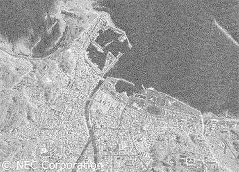
One of the key challenges in utilizing satellite imagery is the amount of work required to manually analyze large areas. In particular, images captured by Synthetic Aperture Radar (SAR) satellites differ significantly from optical images as shown in the following Photo and often require expert knowledge for interpretation due to their unfamiliar visual characteristics. This reliance on specialists for manual analysis has been a major barrier to the widespread adoption of satellite imagery-based solutions.
To address this challenge, NEC is developing a system that combines its expertise in satellite image analysis with rapidly advancing technology in Large Language Models (LLM). This system enables non-specialists to efficiently extract relevant information and streamlines the use of satellite data for a wide range of applications.
This paper provides an overview of NEC’s system currently under development that integrates satellite image analysis with LLMs. It also introduces the potential business applications and prospects of this integrated approach.
2. Satellite Image Analysis Integrated with an LLM
The Satellite Image Analysis x LLM system integrates satellite image analysis with an LLM in a chat-based interface powered by advanced AI, allowing users to intuitively access and interpret a wide range of insights. By leveraging this system, users without specialized expertise can efficiently extract and analyze information from satellite imagery and its corresponding analytical data.
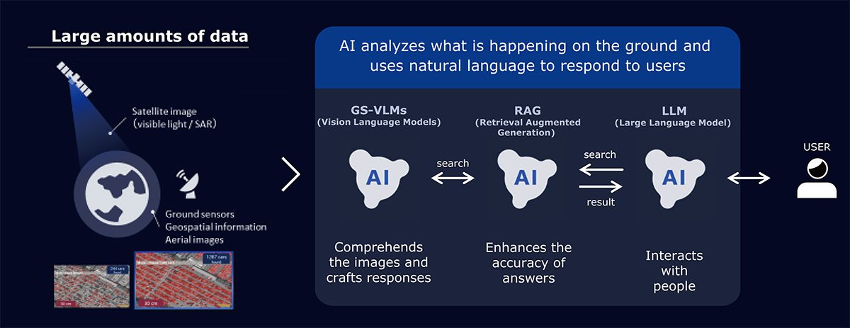
Fig. 1 provides an overview of the system, which operates through a structured, multi-stage process. First, an AI engine equipped for image recognition and signal processing integrates satellite imagery with geographic information (such as maps) and linguistic data; it analyzes the images to extract essential insights. Next, a Retrieval-Augmented Generation (RAG) framework handles user queries by filtering and selecting the most pertinent information from the analytical results and generates responses using an LLM. By seamless orchestrating multiple AI models, NEC’s system delivers fast and precise information to users.
 Click to Enlarge
In the following sections, we introduce the key features of this system through specific disaster response applications.
2.1 Situational Awareness from Wide-area Data
In the aftermath of a disaster, local governments must quickly assess affected areas to prioritize rescue operations and identify safe evacuation sites for residents.
NEC’s system enables users to efficiently interact with AI for a comprehensive understanding of the disaster situation, extract what affected areas are key, and review real-time images—all in a streamlined and intuitive process. Fig. 2 illustrates an example of its application in a large-scale earthquake. When a user enters the prompt, “Please describe the damage in XX city,” the system generates a summary of changes before and after the earthquake. When asked, "Which areas should be prioritized for underwriting?" it identifies the most affected areas with explanations. In addition, when users request, “Show images of this area from social media,” the system retrieves and displays relevant images sourced from social networking service platforms. This functionality is made possible by linking satellite image analysis data with map information and converting it into a format that allows easy searching of location names, building names, and other relevant details.
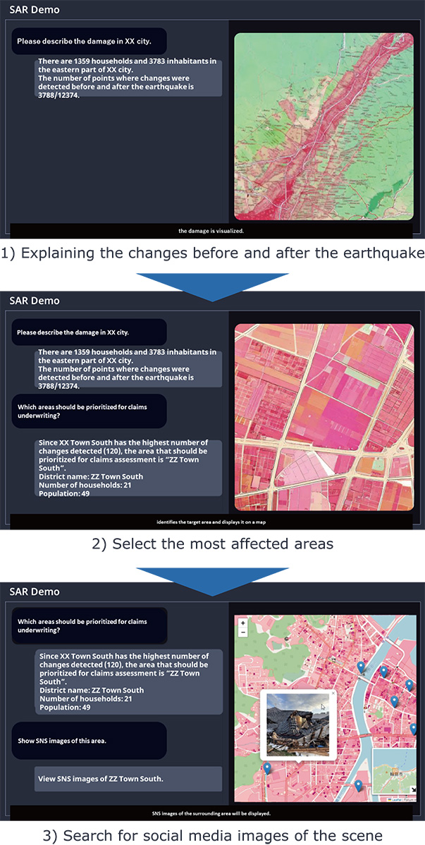
The key technology supporting this feature is NEC’s proprietary time-series data analysis for SAR satellite images. SAR satellite images, captured using microwaves, contain both brightness (intensity) and waveform cycle (phase) information. In particular, by using phase data, it is possible to find subtle changes with high sensitivity, which is difficult to do with ordinary images. NEC’s advanced image processing technology enables pixel-level change detection in SAR time-series images, allowing for precise identification of disaster-induced alterations. Conventional image processing methods rely on detecting shape changes in clusters of adjacent pixels, making it difficult to pinpoint changes in densely built environments. In contrast, NEC’s technology enables precise pixel-level analysis, allowing for more accurate mapping of changes to specific locations and structures.
2.2 Detailed Assessment of Building Damage
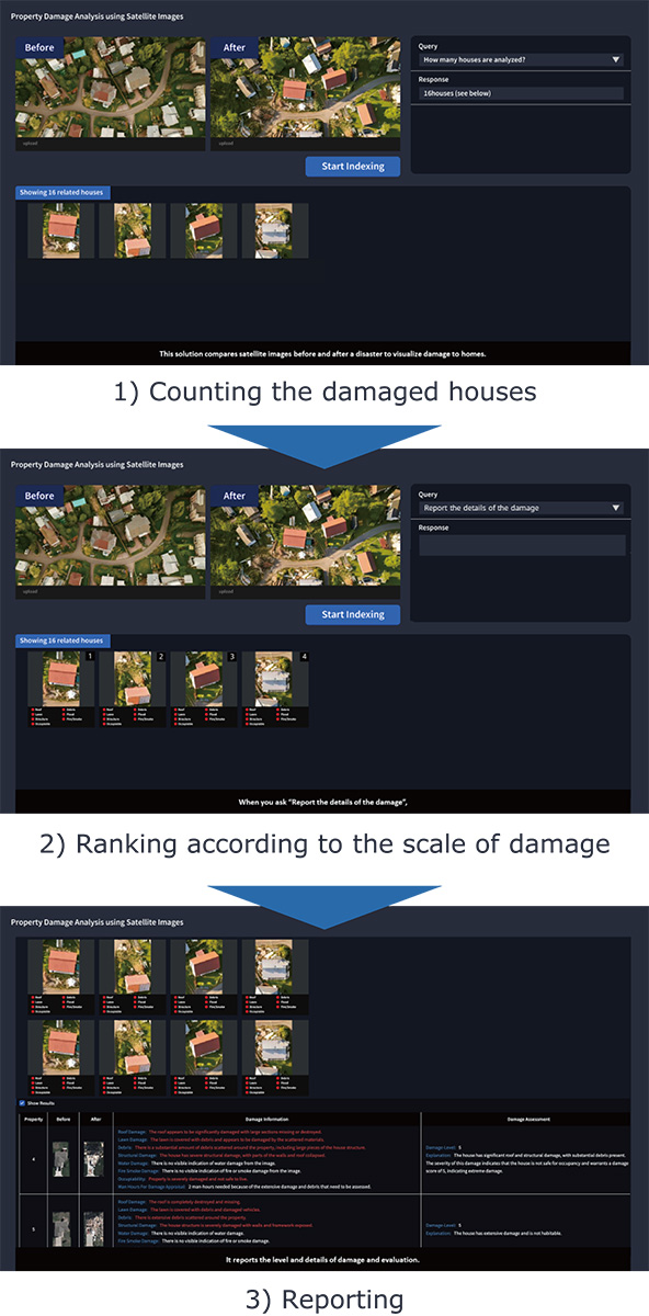
In order for victims to rebuild their lives and businesses after a disaster, it is important to quickly assess the damage to properties such as homes and complete insurance claims so that they can receive the necessary funds and compensation as soon as possible. The integration of satellite image analysis with an LLM in the system allows for objective and rapid damage assessment of the properties by comparing satellite images taken before and after a disaster. Fig. 3 illustrates an example of how the system is used in disaster situations. When the system is prompted with a request such as "Count the damaged houses in the image," the AI detects and tallies the affected buildings, displaying individual images for each damaged property. If asked to "Rank according to the extent of the damage," the system evaluates multiple indicators—including roof and structural damage, flooding, and fire occurrence—and presents a comprehensive assessment. The system can also generate detailed damage assessment reports based on the extracted information.
This capability is achieved by dynamically switching between relevant analysis data based on prompts and queries entered by the user. To meet the diverse needs of users, this system provides over 100 image recognition/signal analysis AI models, ranging from general-purpose to complex.
Running all AI models simultaneously to pre-analyze and store every possible data outcome would be computationally inefficient. To optimize processing efficiency, the system adopts a unique approach: it initially processes images using a lightweight, general-purpose AI model to retain basic analysis results. When a user query is received, the system selectively activates specialized AI models tailored for specific types of analysis, progressively refining the extracted information. This approach ensures high-quality responses while significantly enhancing computational efficiency.
2.3 Presentation of Quantitative Information
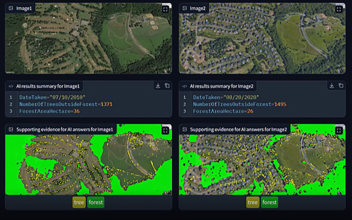
In the previous use cases, providing numerical data—such as the number of damaged buildings—is essential to support effective decision-making. While Vision Language Models (VLMs), a type of generative AI that converts images into text, have advanced rapidly in recent years, current VLMs still struggle with high-precision detection of numerous small objects and segmentation of specific areas. To address this issue, the integrated satellite image analysis and LLM system includes a customized foundational AI model specifically optimized for large-scale object detection and segmentation within images. By combining this model with an LLM, the system allows users to obtain more precise, numerically quantified information.
A practical example of this capability is forest monitoring for environmental assessment, as illustrated in Fig. 4. When the system is prompted with "Show the changes in tree volume over two time periods," it automatically extracts individual trees within and outside designated forested areas from satellite images captured at different times. The system then provides a quantitative comparison of the changes.
 Click to Enlarge
3. Future Business Prospects
In terms of future business prospects for this system, we intend to expand the sensing solutions for dealing with climate change. Specifically, we will use information observed by satellites and combine it with land and building registry information and hazard maps to promote the visualization of detailed and more accurate disaster risks. Furthermore, we are considering this technology will be a crucial component in realizing NEC Digital Adaptation Finance, which is currently under development by NEC. In order to establish NEC Digital Adaptive Finance, it is important to scientifically measure and quantify disaster risk in the wide and narrow areas of the target region, but by combining this technology with other measurement technologies and quantifying disaster risk to assign appropriate values, it is expected to create a solution that will contribute to the creation of financial options to hedge against disaster damage caused by climate change.
References
Authors’ Profiles
TODA Masato
Professional
Principal Researcher
Visual Intelligence Research Laboratories
Professional
Principal Researcher
Visual Intelligence Research Laboratories
SENZAKI Kenta
Professional
Principal Researcher
Visual Intelligence Research Laboratories
Professional
Principal Researcher
Visual Intelligence Research Laboratories
CHAKRADHAR Srimat
Department Head
NEC Laboratories America
Department Head
NEC Laboratories America
SANKARADAS Murugan
Senior Researcher
NEC Laboratories America
Senior Researcher
NEC Laboratories America
DEBNATH Biplob
Senior Researcher
NEC Laboratories America
Senior Researcher
NEC Laboratories America
MIN Martin Renqiang
Department Head
NEC Laboratories America
Department Head
NEC Laboratories America
COSATTO Eric
Senior Researcher
NEC Laboratories America
Senior Researcher
NEC Laboratories America