Global Site
Displaying present location in the site.
Development of the Earth Observation Satellite “DAICHI” (ALOS)
Vol.6, No.1 April 2011, Special Issue on Space SystemsThe Advanced land Observation Satellite "DAICHI"(ALOS) is one of the world's largest class earth observation satellite launched on January 24, 2006. The primary mission of "DAICHI" is obtaining enormous volume of image data for global topographic mapping and emergency disaster monitoring of the disaster-struck area. It has three remote sensing instruments (PRISM, AVNIR-2 and PALSAR) for the precise ground surface observation.
This paper describes practical applications of the images obtained via the three remote sensing instruments over the five year period subsequent to the launch and the ways that the obtained data may contribute to the social infrastructures affecting the lives of the people both inside and outside Japan.
1. Introduction
The "DAICHI" (ALOS:Advanced Land Observation Satellite) is an earth observation satellite that had been developed by NEC acting as the prime contractor. It was launched on January 24, 2006 from the JAXA Tanegashima Space Center by the H-IIA launch vehicle No.8. "DAICHI" is one of the world's largest class earth observation satellites and is still continuing on its observation mission.
The mission objectives of the "DAICHI" include; 1) global topographic mapping; 2) regional topography observations; 3) disaster situation monitoring, and; 4) underground resources surveys. The "DAICHI" has three remote sensing instruments for the precise observation of the Earth's land area. These are the Panchromatic Remote-sensing Instrument for Stereo Mapping (PRISM), the Advanced Visible and Near Infrared Radiometer type 2 (AVNIR-2), and the Phased Array type L-band Synthetic Aperture Radar (PALSAR). In order to utilize fully these data obtained by three remote sensing instruments, three advanced technologies were developed: low thermal distortion structure, high-speed and large-capacity mission data handling capability and precision satellite position and attitude determination capability. In addition, we developed a Precision Pointing, geo-location Determination System (PPDS). This system functions as a part of ground processing system for improving the location determination accuracy of the observation data that enables determination of a location on the ground surface within an error of a few meters from a height of 700 km.
With regard to the usage of the obtained data, its application as a public infrastructure is being verified by employing it for "global topographic map making and updating," "regional observation for ensuring harmony between the environment conservations and development strategies," "situation monitoring of large-scale disasters inside and outside Japan" and "underground resources surveys inside and outside Japan."
2. Outline of the "DAICHI" mission
(1)External view of satellite in orbit and specifications
Fig. 1 shows external views of the "DAICHI" satellite on orbit and Table shows its main characteristics.
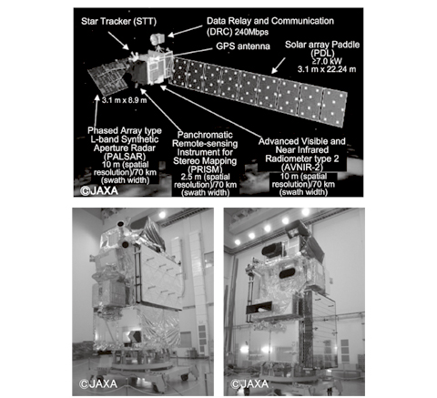
Fig. 1 External view of the "DAICHI."
Table Main specifications.
(2)Observation sensors
The "DAICHI" has three remote sensing instruments of ground surface observation.
1) PRISM
The PRISM is a sensor for observing the ground surface using the visible wavelength band. In order to obtain topographic data including elevations; the PRISM is comprised of three telescopes for quasi-simultaneous observations of the forward, nadir and backward views. These sensors observe the ground surface as three-dimensional image data with a spatial resolution of 2.5m and a swath width of 35 or 70 km.
2) AVNIR-2
The AVNIR-2 is a visible and near infrared radiometer for obtaining data on various land usage and vegetation type with 10m spatial resolution and a swath width of 70 km.
3) PALSAR
The PALSAR is the improved synthetic aperture radar and is ideally suited to detect changes in topography and geology from microwave backscattering of the ground surface. This sensor is capable of continuous observation regardless of day/night or weather conditions. It features three observation modes. These are; a high-resolution mode for observation with a spatial resolution of 10m and a swath width of 70 km, the broad-area mode for observation of swath width from 250 to 350 km, and the multi-polarization mode.
3. Technologies Adopted for Broad-area, Precision Observation
3.1 Low Thermal Distortion Structure
In order to ensure the performance and pointing control accuracy of the optical sensors, it was necessary to develop a structure with low thermal distortion and deformation.
The thermal distortion of the "DAICHI" was reduced by adopting a truss type construction that used a low thermal distortion material. This choice has made it possible to ensure proper load transfer during launch phase and low thermal distortion on orbit.
With the PRISM, which requires extremely high pointing accuracy, was installed on a highly rigid and low thermal distortion structure called the optical bench with the precision Star Tracker (STT) that is used as the attitude reference on orbit. The technology applied in the development of the low thermal distortion structure is as follows:
- 1)Carbon-fiber reinforced plastic (CFRP) laminate design for minimization of the coefficient of thermal expansion.
- 2)Minimization of thermal deformation of the joints between truss members.
- 3)Use of CFRP with high thermal conductivity for reducing thermal deformation due to temperature gradient.
- 4)Use of a resin with low moisture absorbing distortion for reducing deformation due to moisture emission from the structure while in space.
- 5)Use of a thermal control technology that reduces thermal distortion by minimizing the temperature variation amplitude of the truss in each turn of orbit.
3.2 High-accuracy Attitude Control System
In order to enable making of 1/25,000-scale maps, which is one of the missions of the "DAICHI", it is required to determine the location on the ground surface (latitude, longitude and elevation) of each observation image obtained as well as to obtain high-quality images. This makes it necessary to improve the pointing stability, pointing and positioning determination accuracy.
To suppress attitude disturbance caused by the Solar array Paddle drive of the Data Relay and Communication (DRC) antenna or the large mirror of the AVNIR-2, the "DAICHI" has a high-torque reaction wheels.
In addition, when driving the DRC antenna or the large mirror of the AVNIR-2, feed-forward control is applied to suppress the satellite attitude disturbance by compensating for the angular momentum caused by the drive. Furthermore, to facilitate image processing on the ground by reducing the effects of the Earth's rotation on the sensor image data, a yaw steering operation is performed, which modifies and corrects the yaw attitude of the satellite continually according to the latitude argument of orbit.
To improve the attitude and pointing determination accuracy, we developed the STT with extremely low bias error and integrated with the inertial reference unit (IRU) on the low distortion optical bench structure where the PRISM is installed. As a result, the satellite attitude can be determined with a accuracy of 3.0 x 10 -4 deg. (equivalent to 3.6 m from an altitude of about 700 km) with the satellite's internal processing, or of 1.4 x 10 -4 deg. (equivalent to 1.7 m from an altitude of about 700 km) when the ground processing is applied additionally.
Regarding the satellite position determination, this is enabled with an accuracy of below 1 m by adopting a GPS receiver featuring dual-frequency carrier positioning and processing of the GPS data on the ground.
3.3 Precision Pointing and Geo-location Determination System (PPDS)
In order to generate high-quality images without distortion of the captured object shapes and with a high absolute location accuracy (latitude and longitude), it is necessary to prepare the information of the satellite position, attitude and observation sensor alignment. To determine the satellite attitude from the attitude sensor information and to estimate the PRISM alignment that varies depending on the thermal distortion, we developed the PPDS (Precision Pointing and geolocation Determination System) to support the "DAICHI". The PPDS uses the observed data of the known ground control points (GCPs) periodically and estimates the variation of orbiting period, annual period and the fixed bias data continually from the obtained information in order to improve image location accuracy.
The PRISM images are geometrically corrected by means of the PPDS data and satellite position determination data obtained with other systems. As a result, the PRISM images achieved absolute pointing accuracy of 7.8 m (RMS) for the nadir, forward views and 8.7 m for the backward view, even when no GCP is in the image. These accuracies are suitable for the updating of the 1/25,000-scale terrain maps conducted by the Japanese Geographical Survey Institute.
3.4 High-speed Data Processing/Transmission System
Since the three remote sensing instruments integrated on the "DAICHI" have high-resolution, they generate an enormous volume of observation data. The total data rate would rise to 1. 36 Gbps, including 960 Mbps from the PRISM (three view data), 160 Mbps from the AVNIR-2 and 240 Mbps from the PALSAR in the high-resolution mode. To transmit these data effectively to the ground, the "DAICHI" applies on-board, real-time compression of the data. Data compression ratios are as follows: PRISM 960 Mbps to 240 Mbps, AVNIR-2 160 Mbps to 120 Mbps.
The compressed image data is transmitted via the Data Relay Test Satellite (KODAMA) at a rate of 240 Mbps in the Ka-band (26.1 GHz), while it is also transmitted directly to the ground at 120 Mbps in the X-band (8.1 GHz). In case communication with the "KODAMA" and ground station is unavailable, the data is stored to onboard data storage temporarily. For this purpose, the "DAICHI" has a solid-state recorder with a large capacity of 96 GBytes.
The "DAICHI" is designed to operate effectively by means of the capability of multiplexing the data of the PRISM, AVNIR-2 and PALSAR according to operation requests and switching the data transmission routes according to each operation.
4. Examples of "DAICHI" Data Usages
Uses for the data acquired from the "DAICHI" are being verified in various fields. It is contributing to protection of natural, social and living environments and safety in Japan as well as globally.
1) Global topographic mapping
Previously, the 1/25,000-scale terrain maps of Japan have been updated based on aerial images and surveys. However, at present, the PRISM data is already in use for this purpose.
As there are many areas in the world for which precise maps are not available, the data of the "DAICHI" is also contributing to the mapping of such areas.
It should also be noted that preparing the terrain data and updating it every day are also essential for the quick moni-toring of situations in the case of a large-scale disaster as well as for initiating relief and recovery measures.
2) Regional topography observation
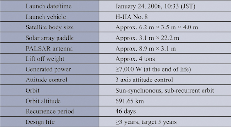
The observation data of the "DAICHI" is continually stored on a worldwide scale and is also used to promote harmony between the global environment conservations and development. For example, as shown in Fig. 2 , the image data of the Amazon region is supplied to the Brazilian government to monitor areas of illegal logging. In addition, the data is also supplied to organizations inside and outside Japan to support a harmonious relationship between the global environment conservations and development needs; e.g. in surveys of vegetation, fauna and flora, monitoring of arable lands usages, surveys of agricultural crops, surveys of fishery, observation of glacier conditions in the Andean Cordilleras and monitoring of world heritage sites such as the Geoglyphs of Nazca.
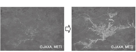
Fig. 2 Decrease in tropical rainforest in the Amazon basin.
3) Disaster situation monitoring
In the case of a large-scale disaster in or even outside Japan, emergency observation is conducted to monitor the situation as it unfolds in the disaster-struck area ( Fig. 3 ).Since the "DAICHI" is observing the whole world periodically, comparison of images before and after the disaster helps identify the scale and to pinpoint aspects of the disaster and also to contribute to relief and recovery measures. Monitoring of diastrophism will also help prepare countermeasures for possible disaster areas in the future.
Fig. 3 Disaster monitoring: Gulf of Mexico oil spill disaster, Off-New Orleans (Left) and interferogram of diastrophism, Chili earthquake (Right).
Since the "DAICHI" observes the same regions periodically, the results of regular basis monitoring of both volcano and submarine volcanic areas can also be used in the prediction of eruptions. The results of periodical observations of floating ice in the Okhotsk Sea in winter are provided as sea ice information to marine transportations, thereby contributing to their safe navigation safety.
4) Underground resources survey
Analysis of terrain characteristics and vegetation using the PALSAR and AVNIR-2 data can support surveys of unexplored underground resources such as oil-bearing strata.
5. NEC's Business Deployment
Based on NEC's long term accumulation of innovative technologies, we have developed and marketed an image processing software package that can create a three-dimensional Digital Elevation Model (DEM) with a horizontal precision of about 10m and a vertical precision of about 5m from the PRISM image data as shown in Fig. 4 . This software package is purchased by governmental organizations for use in global topographic mapping procedures both inside and outside Japan.
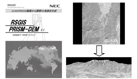
Fig. 4 Example of 3D image processing of the Myogi-san Mountain (Bird's-eye view).
We are also conducting studies for monitoring the effects of natural gas mining on the environment and facilities by detecting crustal elevation changes around the gas field areas by means of the application of interferometer processing to the PALSAR image data under guidance of the Earth Remote Sensing Data Analysis Center (ERSDAC).
We are expanding the usage of "DAICHI" observation image data in support of new fields, countries and organizations and are path finding new business in these areas as described above.
6. Conclusion
The on-orbit operation of the "DAICHI" has already lasted for its target life of five years. However, as the satellite is still in good health and a sufficient amount of propellant remains, it is expected that the satellite observation period can be extended.
The "DAICHI" will continue to contribute as a useful public infrastructure that serves to protect the natural, social and living environment and safety in Japan as well as globally. At the same time, we will also support the continuation of its fruitful operation by adopting a supportive role for the "integrated space utilization systems" that are scheduled for promotion by NEC in the near future.
Authors' Profiles
WATANABE Satoru
Senior Manager
Space Systems Division
Aerospace and Defense Operations Unit
Senior Manager
Space Systems Division
Aerospace and Defense Operations Unit
HIRAO Akihiro
Manager
1st Engineering Department
Space Systems and Satellite Information Systems Division NEC Aerospace Systems, Ltd.
Manager
1st Engineering Department
Space Systems and Satellite Information Systems Division NEC Aerospace Systems, Ltd.