Global Site
Displaying present location in the site.
Positioning Solutions for Communication Service Providers
Vol.17 No.1 September 2023 Special Issue on Open Network Technologies — Network Technologies and Advanced Solutions at the Heart of an Open and Green Society PDF
PDFAs smartphones gain popularity, services such as map apps that use location information have become an essential part of people’s everyday lives. In recent years, location information has also begun to be used for a variety of purposes, such as autonomous driving, construction machinery, and drones. While the usage scenarios of location information vary, the demand for improved positioning technology is increasing. Against this background, NEC offers positioning solutions for communication service providers (CSPs) that achieve enhanced accuracy, reduced positioning time, and expanded coverage areas. This paper introduces NEC’s commitment to improving positioning technology and providing positioning systems for CSPs.
1. Introduction
With the proliferation of smartphones, map apps, child trackers, and other services that utilize location information from mobile devices are being used on a daily basis.
In recent years, the use of location information has expanded to encompass applications such as autonomous driving control for vehicles and drones as well as analysis of trade areas and foot traffic data. As a result, the requirements for positioning technologies are now diversified. In other words, various positioning technologies are now needed. For example, there is a need for real-time and high-precision positioning for autonomous driving control, vertical positioning to track foot traffic on each floor of a commercial building, and positioning solutions for areas with limited satellite signal reception such as indoor environments or areas surrounded by tall buildings.
In this paper, we introduce NEC’s approach to positioning technology and positioning systems for communication service providers (CSPs).
1.1 Location-based services from CSPs
CSPs provide the following major location-based services (LBSs).
- (1)Services for individual users
- Services that provide location information for use with map apps
- Services such as a lost smartphone finder or child tracker that locates the position of objects from a remote site
- Services to provide location information of callers to emergency response agencies (police, coast guard, fire department, etc.) for emergency calls
- (2)Services for corporate users
- Service to track the locations of delivery vehicles
- Service to track the locations of IoT devices
Location information is now used in a wide spectrum of applications, ranging from services that make people’s lives more convenient to systems that are part of the social infrastructure essential for human life.
1.2 Positioning systems
Positioning is the process of determining the current location of a target by measuring its position relative to a reference point whose exact position is known.
Mobile devices primarily adopt positioning methods that use radio waves from global navigation satellite systems (GNSSs), including the Global Positioning System (GPS). However, relying solely on the GNSS signals received by the device results in a number of problems such as the prolonged time required for positioning, compromised accuracy due to various error factors, and the inability to use the system in areas that have no reception because radio waves cannot reach it. To solve these problems, the development of a positioning system with enhanced capabilities is required. Not only does a positioning system perform positioning, but it also plays role in working in conjunction with systems that provide LBSs. Consequently, a positioning system is indispensable for providing LBSs.
2. NEC’s Commitment to the Positioning System Business
For more than two decades since the introduction of GNSS-enabled mobile phones, NEC has been providing positioning systems for CSPs. During this time, NEC has acquired expertise and experience by keeping up with advancements in positioning technology, starting with support for the communication standards of the second generation of mobile communication systems (2G) and continuing with the current fifth-generation mobile communication system (5G).
2.1 New technology initiatives
High-precision positioning and vertical positioning have come into the spotlight recently as new technologies.
2.1.1 5G base station positioning
In 5G, a technology is being developed to achieve high-precision positioning by taking advantage of the linearity of radio waves at high frequencies (millimeter waves) used and analyzing the angles and arrival times of the received waves from multiple base stations.
2.1.2 High-precision (cm level) positioning
The demand for high-precision positioning for use with construction equipment and drones is growing. Although the accuracy of the positioning method used in typical smartphones ranges from a few meters to tens of meters, the use of dedicated antennas and correction data enables high-precision positioning with accuracies on the order of a few centimeters. The correction data includes information on the magnitude of errors caused by ionospheric delays specific to each area. This information is used to improve accuracy.
Correction data is usually distributed to each device via the Internet. However, by transmitting data all at one time from a base station, it is possible to distribute the data to a larger number of devices and reduce the network load.
2.1.3 Height positioning and floor-level positioning
To measure the height of each floor in multistory buildings, positioning sensors have commonly been installed inside the building. However, positioning based on barometric pressure is now considered a promising technique. Pressure-based positioning requires technology to compensate for various error factors, such as changes in atmospheric pressure, but there is no need for equipment to be installed inside the building, thus enabling positioning over a wide area at a low cost.
This pressure-based positioning technique has already been adopted in the United States for use with emergency calls as a method to identify the floor of a building that a person is calling from.
2.2 Efforts to improve positioning accuracy
The accuracy of positioning is affected not only by the performance of the positioning system but also by external factors such as the receiving sensitivity of a device, satellite navigation conditions, and the locations of adjacent base stations or physical obstacles such as high-rise buildings. A multifaceted analysis is therefore needed to evaluate and improve the accuracy of the positioning system, and specialized knowledge and experience are also required.
NEC is engaged in the R&D of positioning systems by leveraging the knowledge and track record NEC has gained through many years of commitment to the development and operation of positioning systems.
3. Introducing the NEC Positioning System
Section 3 introduces several of the positioning systems that NEC offers to CSPs.
Our positioning system provides the functions of location information services in collaboration with the core networks of CSPs.
3.1 Assisted GPS
Assisted GPS (A-GPS) is a system designed to achieve quick and high-precision positioning from the viewpoint of convenience and emergency response. Conventional GNSS positioning where only data from devices is used takes approximately one minute from the time signals (navigation messages) are received from the satellites required for positioning to the time when position information is available. In comparison an A-GPS sends data to the terminal to assist in receiving navigation messages, shortening the terminal’s processing time and achieving high-speed positioning. In addition, by performing positioning processing with A-GPS, the load on the terminal can be reduced.
3.1.1 Use cases
Assisted GPS supports the following three major types of use cases.
- (1)Mobile originated location request (MO-LR)
The target device for positioning itself is the starting point for location requests. This location request type is used, for example, when people use map apps to identify their locations. - (2)Network induced location request (NI-LR)
The core network is the starting point for the location request to determine the position of the target device. This location request type is used to notify call centers known as a public-safety answering points (PSAP) when, for example, the core network relays emergency calls and an NI-LR is used to obtain the location information of the caller. - (3)Mobile terminated location request (MT-LR)
A third party other than the target device is the starting point for the positioning of the device. For example, it is used in child monitoring services that enable parents to track their children’s locations or in situations where the PSAP requests the location information of the caller upon receiving an emergency call.
3.1.2 Positioning methods
A-GPS uses multiple positioning methods on demand.
- (1)GNSS positioning
When a positioning request is received, the A-GPS receives information about the base station that the device in question is using for voice calls and data communications and then identifies the area where the device is located based on the location information of the corresponding base station. By providing the device with GNSS assistance data that can be received in the specified area, the time required for the device to capture GNSS signals and receive navigation messages can be reduced. The assistance data includes navigation messages from GNSS satellites visible from the corresponding area, the direction and distance of GNSS satellites as perceived from the device, the Doppler effect due to relative speed, and other information required for positioning as well as information to assist in signal acquisition.
The device is capable of performing positioning by receiving the information necessary for positioning and acquiring signals, but it can also perform the processing for positioning by using A-GPS. There are some advantages when positioning is performed by A-GPS. For example, the power efficiency of the device can be improved, and the positioning accuracy can be enhanced by using a positioning method not supported by the device. - (2)Base station positioning
In this technique, positioning is performed in accordance with the information of the base stations from which the device is receiving signals. Positioning results are obtained by identifying the area covered by the corresponding base station by using the location and the estimated radio wave range of the base station with which the device is communicating as the basis for calculations. Also, when the device receives signals from multiple base stations, more accurate positioning results can be obtained by identifying the points where the coverage areas of the base stations overlap. It is also possible to choose Enhanced Cell ID or Observed Time Difference Of Arrival (ECID/OTDOA) as the positioning method in accordance with the information that can be obtained by the device. ECID is a positioning method that uses signal strength, radio wave quality, reception timing, and other information, and OTDOA is a positioning method that uses the time differences in signals to receive positioning signals. By supporting the ECID/OTDOA base station positioning methods, A-GPS can achieve high-precision positioning even in environments where GNSS is unavailable.
3.1.3 System configuration
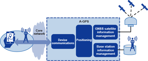
A-GPS is mainly composed of the following functional components: one that facilitates communication with the device through the core network, one that performs positioning, one that analyzes and manages navigation messages from GNSS, and one that manages the location and estimated radio coverage for each base station. Thanks to these functional components, A-GPS provides the device with assistance data and achieves positioning using GNSS and base stations (Fig. 1).
3.2 Emergency location information systems
An emergency location information system (E-LIS) is an emergency call location notification system. The E-LIS has two functions: one to notify the PSAP in the appropriate jurisdiction of the caller’s location and provide such information upon the placement of the emergency call, and the other to obtain the caller’s location information in response to a request from the PSAP.
Notification of emergency call locations is a function that is mandatory for CSPs that handle emergency calls to be introduced and is stipulated in the “Regulations for Telecommunications Facilities for Telecommunications Business” of the Ministry of Internal Affairs and Communications of Japan.
3.2.1 System configuration
The E-LIS’s functional components support several generations of core networks. In this paper, we use the function names used in 4G and 5G.
- (1)Gateway Mobile Location Center
The Gateway Mobile Location Center (GMLC) is a functional unit that provides the caller’s location information to the PSAP in the appropriate jurisdiction and notifies them that an emergency call has been placed. It works in conjunction with the core network and A-GPS when an acquisition request for location information is received from the PSAP. This location information is then sent to the relevant PSAPs across Japan. - (2)Location management function
The location management function (LMF) is a functional component that locates the current location of the caller. Because the LMF is a functional part that is linked with the core network, function groups are arranged by generation, for example, the Evolved Serving Mobile Location Centre (E-SMLC) for 4G and the LMF for 5G.
The positioning method used here is base station positioning, which features the ability to acquire the location information in a short period of time after receiving a positioning request. This makes it possible to immediately notify the PSAP of the caller’s location and provide location information.
3.2.2 Collaboration with A-GPS
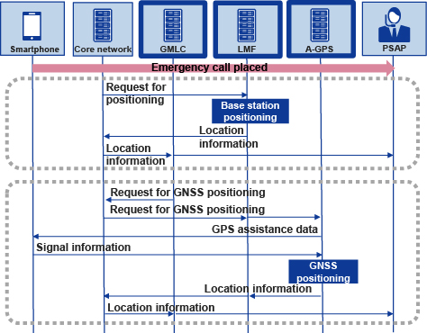
Both base station positioning and GNSS positioning systems are used for emergency calls in Japan. The E-LIS performs base station positioning to quickly obtain information about the approximate location when an emergency call is placed. Then GNSS positioning is performed in collaboration with the A-GPS to obtain more accurate location information. Adoption of this approach ensures that the PSAP is notified of location information as quickly as possible in critical emergency situations (Fig. 2).
4. Conclusion
In this paper, we introduce our efforts in positioning technology and positioning systems. In addition to positioning accuracy, high levels of availability and operability are also essential for positioning systems for CSPs to serve as social infrastructure. NEC is committed to developing high-quality positioning systems by leveraging our experience in the development of core systems for CSPs. It is expected that the use of location information will keep expanding and its importance as social infrastructure will also increase. NEC will continue to contribute to the development of LBSs and the achievement of a safe and secure society through the provision of positioning solutions.
Authors’ Profiles
OYAMA Hiroki
Director
Mobile Core Department
Director
Mobile Core Department
TSUMURA Shusuke
Professional
Mobile Core Department
Professional
Mobile Core Department
OHSHIO Keiichi
Assistant Manager
Mobile Core Department
Assistant Manager
Mobile Core Department
MAKINO Kanako
Assistant Manager
Mobile Core Department
Assistant Manager
Mobile Core Department
YOSHIDA Kazuki
Mobile Core Department
Mobile Core Department