Global Site
Displaying present location in the site.
Development of a GPS-based Aircraft Approach and Landing System (GBAS: Ground Based Augmentation System)
Technologies for Achieving Digital Transformation (DX) of Social Systems: DX of Airports PDF
PDFNEC has developed Japan’s first operational Ground Based Augmentation System (GBAS), a landing guidance system that uses GPS to support aircraft approach and landing, and delivered it to Tokyo International Airport. NEC has developed and manufactured a variety of important social infrastructures such as air traffic control systems, radar systems, navigation systems, and landing guidance systems that contribute to the safety, security, and efficiency of aviation.
Compared to conventional landing guidance systems, GBAS can provide information on multiple approach paths with a single system, thereby reducing installation and operation costs. In addition, depending on the installation environment of the airport, GBAS is expected to enable a flexible approach and landing.
1. Introduction
Since the 1940s, commercial aircrafts have used an instrument landing system (ILS), which uses radio waves to guide the aircraft into and out of the airspace, for a safe landing.
On the other hand, to meet the ever-increasing demand for aviation, a shift to satellite navigation using positioning satellites such as the Global Positioning System (GPS) is underway.
Since the 1990s, research and development of Ground-Based Augmentation System (GBAS), which augments the navigation accuracy and safety of satellite navigation, has been conducted in the United States and other countries to enable commercial aircraft to enter and land using GPS.
NEC began research and development of GBAS in the late 1990s. We received an order to develop a prototype GBAS for the Electronic Navigation Research Institute of the National Institute of Maritime, Port and Air Technology (hereinafter referred to as Electronic Navigation Research Institute) and installed it at Sendai Airport in 2001 and Kansai Airport in 2010, thereby cultivating our knowledge and basic technology of GBAS. Then, in 2016, we received an order from the Civil Aviation Bureau of the Ministry of Land, Infrastructure, Transport and Tourism (hereinafter referred to as the Civil Aviation Bureau) for GBAS for Tokyo International Airport (hereinafter referred to as Haneda Airport) as the first operational system in Japan, and delivered it in March 2020. This paper presents an overview of GBAS, its technical issues, and our response to them.
2.Overview of GBAS
2.1 What is GBAS?
GBAS is a landing guidance system that uses GPS to support the approach and landing of commercial aircraft. GPS is widely used in car navigation systems and cell phones to determine location information, but the location information obtained from GPS cannot guarantee the accuracy and safety required for aircraft approach and landing. For this reason, GBAS generates and broadcasts augmentation information (error correction data*1, integrity information*2, and approach path information*3) on the ground to guarantee the accuracy and safety of GPS positioning. By applying the augmentation information broadcasted from the ground to the GPS signal, the aircraft achieves a safe approach and landing.
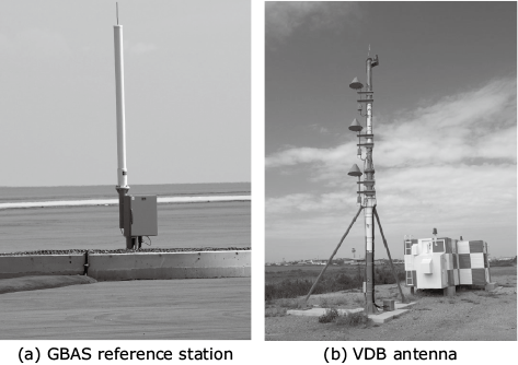
Fig.1 and Photo show the configuration and appearance of the GBAS. As shown in the figure, the GBAS consists of a GBAS reference station, a GBAS processor, and a VHF Data Broadcast (VDB) antenna.
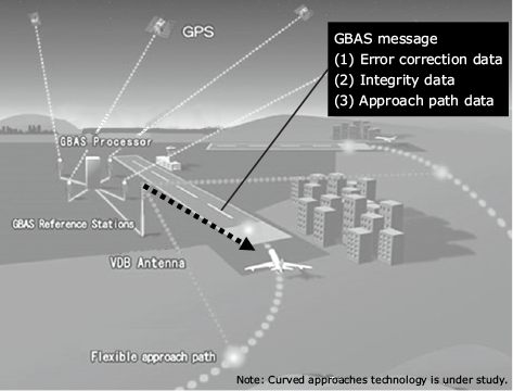
The GBAS reference station receives signals from GPS and transmits the received GPS data to the GBAS processor, which uses the received GPS data transmitted from the GBAS reference station to generate augmentation information. The generated augmentation information is broadcast from the VDB antenna to the aircraft as a GBAS message. The GBAS processor also monitors GPS satellite failures and ionospheric anomalies, which are situations where satellites cannot be used due to sudden changes in the ionosphere. If a satellite failure or ionospheric anomaly is determined to have a negative impact on positioning, it is not included in the GBAS message, thus avoiding problems with approach and landing.
- *1Information to compensate for GPS ranging errors.
- *2Information on the reliability of GPS positioning errors to guarantee safety.
- *3Information that indicates the approach path to the runway used by aircraft when landing.
2.2 Advantages of GBAS
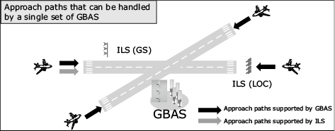
Conventional ILS requires one system for one runway and one approach path. GBAS, on the other hand, can provide information on multiple approach paths with a single GBAS message broadcast from a single system, thus reducing maintenance costs. Fig.2 shows an example of two runways with approach paths from both sides, where a single system ILS can support only one approach path, while a single system GBAS can support four paths.
Since GBAS provides digital data to the aircraft, it is expected to enable a flexible approach and landing depending on the installation environment of the airport.
3. GBAS Technical Issues and Their Resolutions
3.1 Ionosphere
The ionosphere is a region at altitudes ranging from about 60 km to more than 1,000 km where the Earth’s atmosphere is ionized by ultraviolet radiation from the Sun. Ionospheric activity is strongly influenced by the Earth’s magnetic field and is discussed in terms of magnetic latitude, which is related to the orientation of the geomagnetic field relative to the horizontal plane (magnetic subduction angle). In low magnetic latitudes, the ionospheric conditions tend to be unstable, and ionospheric activity tends to have a strong influence on GPS-based positioning. Japan has a low magnetic latitude relative to its geographic latitude, making it susceptible to the influence of the ionosphere.
3.2 Effect of Ionosphere on GBAS
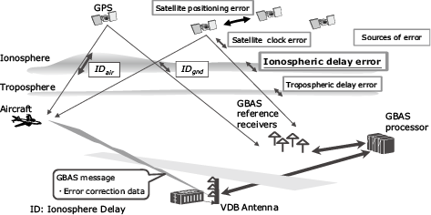
The main sources of error in GPS positioning are satellite position error, satellite clock error, ionospheric delay error, and tropospheric delay error (Fig. 3). In GBAS, the geometric distance to the satellite is determined accurately using the precisely surveyed antenna position of the GBAS reference station and the satellite position calculated from the orbital information broadcast by GPS. The geometric distance to the satellite is accurately determined. Next, the difference between the geometric distance and the actual distance to the satellite observed by the antenna is calculated to estimate the error in the GPS signal, which is then broadcast to the aircraft as error correction data.
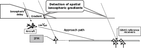
In low magnetic latitudes where the ionosphere is unstable, the accuracy of the error correction data may be affected by the large difference in the ionospheric delay, even though the observation locations are not far apart. The change in the ionospheric delay depending on the observation location is referred to as the ionospheric spatial gradient.
When the ionospheric spatial gradient is small and the ionospheric delay observed by the GBAS reference station (IDgnd) is equivalent to the ionospheric delay observed by the aircraft (IDair), the correction accuracy is good. However, as the ionospheric spatial gradient increases, the ionospheric delay observed by the aircraft and the GBAS reference station becomes less equal, and the correction accuracy deteriorates. Fig.3 shows the situation where IDair and IDgnd are significantly different.
The large ionospheric spatial gradients that frequently occur in low magnetic latitudes have been the biggest challenge in the practical application of GBAS.
3.3 Addressing the challenges of the operational use of GBAS with IFM
NEC’s GBAS introduced Ionospheric Field Monitor (IFM)1), a technology conceived by the Electronic Navigation Research Institute (ENRI) and put to practical use by NEC through the prototype development described above, to monitor the ionospheric spatial gradient.
Fig.4 shows the situation where the amount of ionospheric delay is not equivalent between the GBAS reference station and the aircraft due to the ionospheric spatial gradient. Only the GPS signal received by the aircraft passes through the region of high ionospheric gradient, resulting in a large correction error. To monitor the ionospheric gradient, the IFM is placed in the direction of the aircraft’s approach path, as shown in Fig.4 . If the ionospheric gradient monitored by the IFM exceeds a certain threshold, the satellite affected by the ionospheric gradient will not be included to be observed for the GBAS message, so that the aircraft will not use the positioning signal generated by the satellite. There are about 30 GPS satellites in orbit, and about 8 to 13 satellites can usually be observed simultaneously over Japan. Therefore, even if we do not use a satellite that is affected by the ionospheric gradient, we can continue positioning using other satellites.
Haneda Airport has six approach paths, as shown in Fig.5 . To cover all the approach paths, IFMs were installed in two locations: the Civil Aviation Bureau facility (IFM1) in the northeast of the airport and the Umihotaru parking area (IFM2) in the southeast. IFM1 is used to monitor the ionospheric spatial gradients affecting the approach from the northeast and northwest, and IFM2 is used to monitor the ionospheric spatial gradients affecting the approach from the southeast.
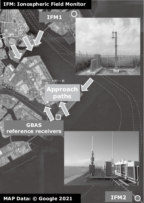
By implementing these two IFMs, GBAS in a low magnetic latitude environment is realized.
4. Conclusion
In this paper, we presented an overview of GBAS, the first operational system of its kind in Japan, installed at Haneda Airport, and related responses to technical issues. To deal with the ionospheric spatial gradient, which has been an issue in realizing GBAS in low magnetic latitude regions, we introduced the IFM and realized GBAS that is compatible with the ionospheric environment in low magnetic latitude regions. In the future, we plan to deploy this system at major airports in Japan, as well as at airports in countries in low magnetic latitude regions.
Finally, we would like to express our sincere appreciation to the Japan Civil Aviation Bureau and the Electronic Navigation Research Institute for their guidance in making this development a success.
Reference
- 1)S. Fujita, T. Yoshihara and S. Saito:Determination of ionospheric gradients in short baselines by using single frequency measurements, Journal of aeronautics, astronautics and aviation, Series A42, pp.269-275, 2010
Authors’ Profiles
INOUE Keiichi
Radio Application, Guidance and Electro-Optics Division
Radio Application, Guidance and Electro-Optics Division
TAGUCHI Tatsuo
Assistant Manager
Radio Application, Guidance and Electro-Optics Division
Assistant Manager
Radio Application, Guidance and Electro-Optics Division
SUZUKI Kazushi
Manager
Radio Application, Guidance and Electro-Optics Division
Manager
Radio Application, Guidance and Electro-Optics Division
KONDO Tempei
Manager
Radio Application, Guidance and Electro-Optics Division
Manager
Radio Application, Guidance and Electro-Optics Division