Global Site
Displaying present location in the site.
Building a Common Smart City Platform Utilizing FIWARE (Case Study of Takamatsu City)
Demonstration and Implementation Examples of Data-driven Smart CitiesAs part of its effort to implement the Ministry of Internal Affairs and Communications' proposal for "Promoting Data Utilization-Oriented ICT Smart Cities" the City of Takamatsu is the first organization in Japan to adopt the FIWARE platform — a common platform that makes it possible for ordinary citizens and businesses, as well government and municipal organizations, to freely access and use public data. Specifically, Takamatsu City has built a system that leverages the power of advanced IoT technology to collect, store, visualize, and analyze data in the fields of disaster management (coping with as a large-scale disaster) and tourism (promotion of sightseeing and MICE), which are both considered as a high priority. In this case study, we will examine in detail the common platform introduced to Takamatsu City and how the city utilizes data in the disaster-management and tourism fields.
1. Introduction
With a view to realizing a city capable of sustainable growth, Takamatsu City in Kagawa Prefecture has introduced a common smart city platform that collects, stores, visualizes, and analyzes data across a broad range of fields.
In this paper, we examine the smart city platform implemented by Takamatsu City. The first in Japan to adopt the FIWARE platform, this system leverages the power of IoT technology and open APIs to collect, store, visualize, and analyze data related to two of the issues the city has to reckon with — disaster management and tourism.
2. FIWARE — A Common Platform for Smart Cities
FIWARE*1 is an open source middleware platform that was developed and implemented under the European Union's FI-PPP project*2. Designed to support the creation of smart cities, FIWARE is already widely used in Europe by municipalities and businesses.
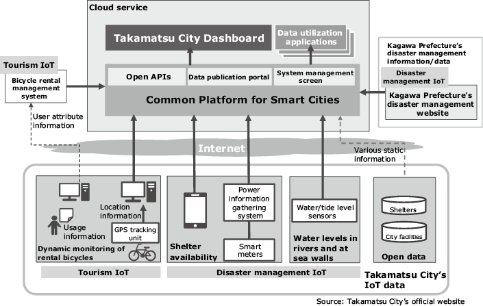
NEC has been a committed partner in FIWARE's development since 2011. We have independently verified the quality of the FIWARE platform and are now offering local governments and area developers a security-enhanced service for smart cities using FIWARE, which we call the Data Utilization Platform Service.
To help solve some of the issues faced in modern urban centers such as revitalization of communities and improvement of safety, this service uses IoT technology to collect comprehensive data in various fields and spheres (for example, disaster management, tourism, transportation, energy, environment, etc.) from various locations throughout the city and region. The accumulated data is stored on cloud servers where it can be shared, analyzed, and processed. The common smart city platform implemented by Takamatsu City is centered on NEC's Data Utilization Platform Service and currently utilizes data related to disaster management and tourism.
- *1FIWARE stands for "Future Internet-ware," and is a next-generation Internet middleware platform developed by FI-PPP in order to enhance Europe's competitiveness in next-generation Internet technology and support the development of smart applications in social and public spheres.
- *2Standing for Future Internet Public-Private Partnership, FI-PPP implemented a five-year project starting in 2011 with a budget of 300 million euros as an ICT project under the EU 7th Framework Programme.
3. IoT-Based Data Utilization Technology in the Disaster Management Field
Two key issues dominate disaster management scenarios in Takamatsu City: (1) the risk of flooding of local rivers caused by localized torrential rain and typhoons, as well as by tsunamis and high tides along the coast — which have been increasing in recent years; and (2) the need to quickly assess shelter requirements and availability should a large-scale disaster occur and the ability to expeditiously provide accurate information to citizens if, for example, a Nankai megathrust earthquake were to occur (something that is expected to happen in the near future with a likelihood of 70 to 80 percent within thirty years).
The system we have designed provides real-time data on river levels, sea levels near seawalls, as well as shelter availability (Fig. 1). Before the implementation of this system, there was no way to detect water levels in real time so checks were performed on the spot by city staff members. Now, thanks to the introduction of this system, we have been able to provide an environment where early-stage disaster measures (swift provision of accurate information to citizens, on-the-spot investigation by city staff, etc.) can be readily managed directly from the city hall by live monitoring of the situation in disaster-struck regions.
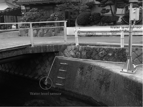
3.1 Visualization of Water Levels in Rivers and Tide Levels at Seawalls
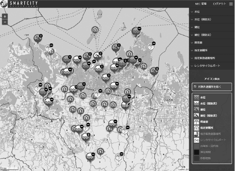
To solve the issue described in (1) above, we installed water and tide level sensors at the observation points designated in Takamatsu City's flood-preventionplan (Photo 1). In addition to the data on water and tide levels collected from these sensors, we also incorporate data regarding water and tide levels, as well as the amount of rainfall provided on Kagawa Prefecture's disaster management website. All of this information is visualized on the Takamatsu City Dashboard (Fig. 2).
(Visualization of Disaster Management Data).
3.2 Visualization of Shelter Availability
Issue (2) was addressed by installing smart meters at designated shelters in Takamatsu City. By collecting the data on power usage conditions from those smart meters and visualizing it on the Takamatsu City Dashboard, we can determined whether or not more shelters need to opened and the status of open shelters.
We also have provided the city staff with a smartphone app that allows them to register the evacuation status — right on the spot at a shelter — onto the Takamatsu City Dashboard when the shelter is open and running.
4. IoT-Based Data Utilization Technology in the Tourism Field
Takamatsu City is focusing on two primary goals in the area of tourism: (1) to explore the development of new tourism resources such as the creation of dining, entertainment or sightseeing activities at night that would encourage tourists to stay overnight, as well as to support and develop local gourmet culture; and (2) to make the city more attractive to foreign tourists by installing multilingual signage, increasing the number of bilingual or multilingual staff, and adopting Universal Design principles.
To help address these issues, we have built a system that tracks usage of bicycles rented out to tourists (including foreign tourists). Facing the Seto Inland Sea, Takamatsu City has few hills and the scenery there is so beautiful that it has become famous, attracting an increasing number of foreign tourists. The relatively flat topography of the city and its surroundings makes it easy for tourists to get around by bicycle, so rental bicycles are commonly used to get to the various sightseeing spots. By tracking the movements of these bicycles, we can collect data that supports the exploration of new tourism resources and shows where services can be improved for foreign tourists (provision of multilingual guides, installation of multilingual signs, provision of language courses for workers in the tourist industry, etc.).
4.1 Visualization of Rental Bicycle Usage Data
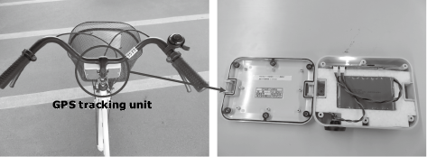
Now let's take a look at how we tried to help address these issues. We incorporated a GPS tracking unit (a device that records travel paths using a GPS) in the rental bicycles (Photo 2). When a bicycle with a GPS tracking unit is returned to a rental bicycle station, the GPS log data in the GPS tracking unit is automatically collected via Wi-Fi. By comparing this data with the user attribute data (nationality, sex, age, usage purpose, etc.) collected beforehand (with user consent), this system is able to analyze the user's movements.
The results of these analyses are stored in the common platform and visualized on the Takamatsu City Dashboard particularized as point of departure, destination, duration of stay, and travel routes (see the shaded areas in Fig. 3).
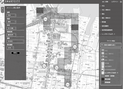
(Visualization of Tourism Data).
5. Conclusion
In addition to tourism and disaster management, Takamatsu City plans to implement the common platform data utilization system introduced in this paper in other areas that fall under municipal. Together with NEC and STNet, the City is studying the construction of a verification environment for a common platform that will allow industrial, academic, private, and public sector entities to freely utilize the data. It is anticipated that the businesses and organizations that make up Partnership for Smart City Takamatsu*3 will take advantage of this verification environment to develop new applications in a variety of different areas such as disaster management, tourism, security, and welfare.
- *3Established in October 2017 under the auspices of Takamatsu City and six companies and organizations. Its objective is to solve local municipal issues through industrial, academic, private, and public collaboration, while promoting a common platform for appropriate and effective utilization of data in the public and private sectors (achievement of a smart city). Thirty companies participated in this council as of the end of April 2018.
- *Wi-Fi is a registered trademark of Wi-Fi Alliance.
- *All other company and product names that appear in this paper are trademarks or registered trademarks of their respective companies.
Authors' Profiles
ISHII Kazuhiko
Assistant Manager
Future City Development Division
Assistant Manager
Future City Development Division
YAMANAKA Atsushi
Manager
Future City Development Division
Manager
Future City Development Division