Global Site
Breadcrumb navigation
Infrastructure Maintenance Management Using SAR Satellite
Monitoring Displacement By Combining Bird’s Eye and Worm’s Eye View
Synthetic-aperture radar (SAR) satellite technology beams microwaves from space to detect subtle displacements on the ground. This application is now entering a new stage. It aims to optimize and enhance the maintenance management of a variety of infrastructure by combining the macro data acquired by SAR with the micro data collected on the ground. Using the proof-of-concept initiatives at Nanki-Shirahama Airport, the potential of using satellite technology for preventive maintenance of infrastructure will be introduced.
How to Deal with Aging Infrastructure
Bridges, tunnels, roads, railroads, embankments, water and sewage systems, and facilities and plants operated by private-sector companies. In Japan, most of these infrastructure were created during periods of high economic growth period from the mid-1950s to the 1970s. The question is, how to deal with the aging of infrastructure that has supported people's lives for almost 70 years. This is becoming a big social issue.
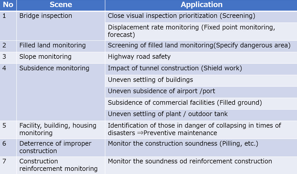
Preventive maintenance needs to be undertaken before aging infrastructure leads to fatal accidents. However, though there is a massive amount of infrastructure, there are resource limitations such as budget, manpower and technology. As an example, bridges must undergo a close visual inspection once every five years. However, there are more than 700,000 bridges in Japan. The amount of people, time, and money that is required to do this is overwhelming.
Using ICT is one way to address this issue. Initiatives such as placing sensors on bridges, using lasers for remote measurement, and sensing using robots and drones are in progress. However, these technologies cannot be used for all inspection operations, and effective use of the data collected are yet to be established. Inspection work has always relied on human effort, and this is still the case today.
Prioritizing Infrastructure Inspections
Preventive maintenance for massive infrastructure spread over large areas. One promising solution is the use of satellites. In particular, a technology known as synthetic-aperture radar (SAR) is driving the future of infrastructure maintenance.
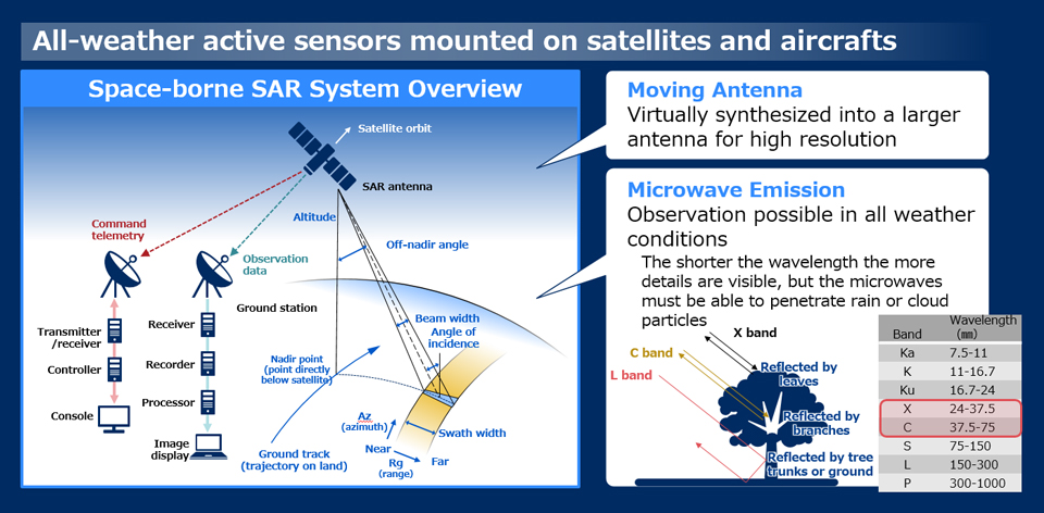
SAR generates images using microwaves transmitted by satellites and reflected off objects on the surface of the earth. Microwaves penetrate clouds and are not affected by light levels, so data can be acquired in any weather and at any time of day. This is one of SAR's main features. Another is its ability to "virtually" create a radar with a huge aperture.
 Larger view
In general, the larger the aperture of a radar, the higher its resolution. Radar units mounted on satellites have small apertures, but combining measurement data from multiple points along a satellite's trajectory allows them to be virtually synthesized as though it were one large radar. This is how SAR technology works, and the name "synthetic-aperture radar" also comes from this feature.
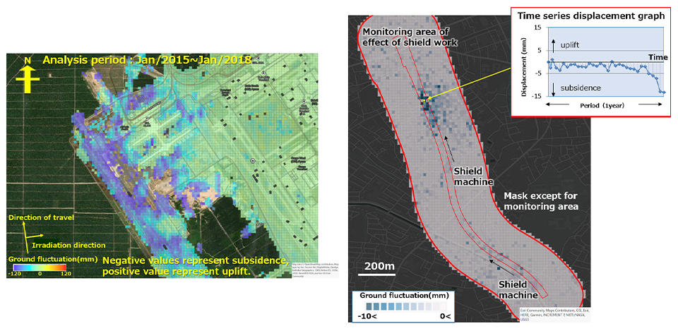 Larger view
Left: Kuala Lumpur International Airport
Right: Shield work area
“This technology not only allows us to observe a wide area ranging from ten to hundreds of kilometers, but also to track minute changes in the Earth’s surface or objects above ground. This is made possible by continuous measurement of the distance between the radar and the ground,”
explains Takakazu Ishii, Senior Expert at NEC's Radio Application, Guidance and Electro-Optics Division. He points out that the main use of SAR in preventive maintenance of infrastructure is in the screening of components to be inspected.
“Infrastructure maintenance moves through a cycle of inspection, evaluation, action, and documentation. SAR plays a vital role at the earliest stage of that cycle, by providing key information that support decision-making of which infrastructure to prioritize for inspection.”
The vast number of infrastructure requiring inspection makes it hard to know which need urgent action and which can wait. SAR can be used primarily to identify those that show a particularly strong displacement trend and prioritize them for inspection, thereby preventing infrastructure from collapsing or any other related incidents before they occur.
“In practical terms, SAR can be used to provide information on things such as damaged bridges, railroad tracks warped by ground shifting, or distorted embankments and port facilities. It can also be used to assess damage to infrastructure after natural disasters such as typhoons or heavy rain.”
NEC Radio Application, Guidance and Electro-Optics Division
 Larger view
Understanding this displacement trend in infrastructure requires high-accuracy measurement and advanced algorithms to analyze the data. This is where NEC's expertise comes into play, says Ishii.
“Displacement has to be understood in each different context, whether in urban areas with a high concentration of man-made structures or remote areas a single building. I am confident that NEC's measurement and data analysis technology is top class.”
NEC developed and operates the ASNARO-2, earth observation satellite, which is equipped with SAR. This means that rapid application of SAR data is NEC's specialty. However, ASNARO-2 alone cannot acquire all the data needed for infrastructure maintenance.
“To understand infrastructure displacement in detail, we need to combine this with other solutions from the range provided by NEC, or with data from other SAR satellites.”
Using Dash Cams to Detect Issues with Roads
Head of Operations Unit
Nanki-Shirahama Airport
What would combining different solutions look like? A proof-of-concept test for one combination was carried out at Nanki-Shirahama Airport in Wakayama Prefecture, Japan.
“Maintenance of infrastructure such as runways at airports is essential, but all airports struggle with limited budgets. This lack of budgets forces airports to limit recruitment, meaning they don't have enough technical staff. It's a problem for all regional airports,”
explains Naotaka Ikeda, head of the Operations Unit at Nanki-Shirahama Airport. Nanki-Shirahama airport opened in April 2019 as a privatized airport, a concession whereby private business owners manage administration of public facilities. The new operators have embraced the principle of "advanced maintenance utilizing IoT" from the very beginning.
“We have tested using IoT technology such as drones and sensors to compensate for lack of manpower, while creating a system that ensures continued safety and security.”
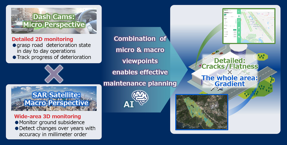
One of those trials was the proof-of-concept test for "Kurumie for Cities", which launched in March 2020. "Kurumie for Cities" is a unique NEC solution that uses footage from car dash cams and an image recognition AI to detect deterioration in road surfaces, etc. Could it be used for runway inspections that previously required human visual inspection? This idea is what led to the proof-of-concept test.
During the test, data related to artificial drainage ditches or aircraft tire tracks that was not "deteriorated" was discarded during repeated tuning of the AI engine, and an automatic detection system was established. Ikeda was thoroughly satisfied by the progress of the test.
“I didn't think such detailed detection was possible. I felt this was a solid lead toward practical implementation.”
Combining Micro and Macro Data
The proof-of-concept test to combine ground data acquired through "Kurumie for Cities" and satellite data was held in November 2020.
“'Kurumie for Cities' can detect deterioration with extremely high accuracy, but there are some things you can't detect from the ground. For example, puddles from mild ruts. My thinking was that finding these kinds of deterioration with SAR would enable more precise maintenance of infrastructure.”
Ikeda expresses this as combining the "bird's eye" and "worm's eye".
SAR can cover three airport infrastructure maintenance work: dynamic observation to detect issues such as runway subsidence, gradient surveys to check runway orientation, and obstacle management to confirm there are no buildings outside the airport blocking aircraft approach routes. On top of that, as mentioned earlier, SAR can also be used for other things such as checking for damage after natural disasters.
 Larger view
“We verified the data from 'Kurumie for Cities' and SAR, and confirmed that combining micro and macro data led to a dramatic increase in the precision with which deterioration were detected. We are proceeding with its implementation as quickly as possible, and we aim to have it as a new method for infrastructure maintenance by mid-2021. We also want to introduce this solution to other regional airports facing the same problems, via the Japan Civil Aviation Bureau of the Ministry of Land, Infrastructure, Transport and Tourism,” says Ikeda.
Through Nanki-Shirahama Airport, preparations for proof-of-concept tests are already underway at two other regional airports. This kind of initiative looks set spread further in future.
“The practicality of the solution is more or less proven, so I want to join NEC in widely sharing this evidence. Japan's infrastructure maintenance technology is world-renowned, so there's every possibility that this could be expanded to overseas airports.”
Airports outside Japan had been approached about using SAR alone, but its practicality had not been clearly demonstrated. Ishii continues,
“Combining SAR with dash cams makes it a usable tool. I want to offer this widely as a solution to the problem of infrastructure maintenance at airports all over the world.”
Establishing a Preventive Maintenance Business
The combination of "Kurumie for Cities" and SAR can be applied to infrastructure maintenance in many fields besides airports. Widespread use in roads maintained by public bodies or for facility inspections by energy and other companies could lead to the establishment of a preventive maintenance business, something Ishii wants to see.
“How can we use technology to support facility managers or local governments who don't have enough resources? By proposing how to respond to this problem, we can contribute to maintaining the safety and security in society as a whole.”
The development of smart cities, or the next generation super cities, is already underway. Cities such as these that are built on IoT and AI technology, require more effective infrastructure maintenance. Japan has always had a high incidence of natural disasters. Leveraging the "bird's eye" and "worm's eye" views—the macro micro data—will certainly be essential to Japanese society for future monitoring, both during normal times, as well as following natural disasters. Needless to say, expanding the use of these technologies will require joint development with a variety of organizations alongside NEC. Ishii's vision is to create businesses that skillfully combine solutions and services from NEC and other sources, with the aim of continuously reducing risk in society.
“I’m not looking to solve problems by ourselves but rather to create custom solutions by working with partners and customers, thereby contributing to bringing about a truly sustainable society. I think this is what the future will be. I want to use SAR effectively, and devote ourselves to ensuring a safe and secure society. That's what I hope for.”
(March 15, 2021)