
Global Site
Breadcrumb navigation
Improving weather forecast accuracy by using SHIZUKU

Until now, Japanese geostationary satellites used for weather forecasting, has mainly been focused on satellite HIMAWARI. However, there are high expectations that observation data obtained from SHIZUKU is also going to be crucial for accurate weather forecasting.
How can the data of SHIZUKU affect weather forecasts? Yoshiaki Sato in charge of technology development of numerical forecast at Forecast Department, Japan Meteorological Agency, tells us how.
Yoshiaki Sato
Data Assimilation Technology Development Officer, Numerical Prediction Division,
Japan Meteorological Agency
Various observation data is the basis of numerical forecast
- Could you begin with explaining the basic mechanism of forecasting weather?
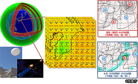
Sato: Certainly. First of all, knowing the “current” situation accurately is especially important in forecasting. For this, various observation data such as current temperature, atmospheric pressure, humidity, wind speed, and wind direction are necessary.
In Japan, data is collected from 160 meteorological observatories, weather radars in 20 locations, observation balloons called “radiosondes”, and radio wave emission devices called “wind profilers”.
Based on such data, we then recreate current weather conditions on computers and calculate how the weather is going to be. This is called numerical forecast.
However, the numerical forecast isn’t published as it is. Experienced forecaster make adjustments to the calculated forecast, which is then published as the official forecast.
-Is the data for weather forecast collected only in Japan?
Sato: No. In weather forecasting, data of one country is not enough, so there is an international rule whereby each country shares observation data from its meteorological organization. The Japan Meteorological Agency receives data from meteorological observatories, ships, balloons and buoys on the sea from each country, and we too provide our data to other countries.
-So artificial satellites play a key role in collecting such data, correct ?
Sato: Exactly. As you know, geostationary meteorological satellite, HIMAWARI, has observed the distribution of clouds and water vapor near Japan from a geostationary orbit about 35,800 km above the equator in Japan. Since its launch in 1977, it continues to observe. The latest HIMAWARI is the 8th one.
-Are there any challenges, and if so, what are they?
Sato: Each satellite has a particular capability, so there are things they can do or cannot do. What HIMAWARI can do is to shoot visible and infrared images.
Visible images are the same as images which we see, and infrared images are images which are shot at night. Like pictures, if there are clouds, it cannot shoot the ground or sea underneath it. Also, since HIMAWARI is on geostationary orbit, it is possible to shoot the observation area frequently, but it’s impossible to collect the data outside that area. These two are the biggest challenges.
The function and role of SHIZUKU
-Can SHIZUKU solve such challenges?
Sato: It would be more accurate to say that SHIZUKU can do what HIMAWARI cannot do, rather than stating that SHIZUKU can solve them. HIMAWARI and SHIZUKU each have their own function and role.
SHIZUKU has a sensor which catches electromagnetic waves such as microwaves emitted by water molecules on the Earth. The electromagnetic waves goes through clouds. In brief, even if there are clouds, SHIZUKU can collect data on distribution of rain and water vapor and the situation on the ground and at sea. For example, sensors on SHIZUKU can get more accurate location information of the eye of a typhoon even if clouds cover the typhoon. It enables us to provide more accurate typhoon information.
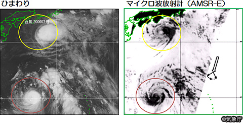
(Right: Data from HIMAWARI Left: Data from microwave radiometer)
Sato: Also, the data may enable us to more accurately forecast changes of weather and enable us to improve warnings and alarms than before.
Another point, SHIZUKU can observe 99% of the Earth’s area in 2 days, so information of areas far from Japan can be gained. This is an important point for us because we need to collect observation data around the world.
-Could you describe in more detail how the data obtained by SHIZUKU is used?
Sato: Firstly, the data collected by SHIZUKU such as sea surface temperature, water vapor amount and precipitation intensity data is sent to JAXA and which is then provided to Japan Meteorological Agency. The agency inputs those data into its computer together with the conventional observation data and makes a numerical forecast.
It takes less than 30 minutes to receive the data from SHIZUKU to Japan Meteorological Agency, so we can get the information in “near real-time”. As I mentioned, the key to accurate weather forecasting is to grasp the “current” situation accurately. No matter how wonderful the data is, it is not useful if it takes too long to receive it. 30 minutes or less would be a satisfactory speed.
-Does SHIZUKU being a Japanese satellite have a meaning to it?
Sato: We need to have reliable data as soon as possible. For this reason, it is really important that SHIZUKU is a Japanese satellite.
In case of overseas satellites, priority is given in providing data to the local meteorological organizations in their own countries, so it could take more time before data is shared outside, and it could also be stopped temporarily due to an incident.
If it is a Japanese satellite, we have high priority, and even if there is a problem, various detailed information such as the response status will be provided promptly.
A continuous satellite operation is the foundation of developing weather forecasting
-Please tell us your expectations of SHIZUKU and other following projects.
Sato: We need to have high quality data sent continuously. It is the expectation of all those involved in weather forecasting. And various observation data are required. If satellite activity stops, we will not be able to obtain such critical data.
Weather forecasting data is evolving daily It has been about 30 or 40 years since the activities of meteorological satellite of each country started, but it has been only the last 10 years that satellite observation data has become really useful. In recent years, the computing performance power has improved, and finally it has become possible to make accurate numerical forecasts using satellite data.
Sato: Computing power will continue to evolve day by day. On the other hand, of course, ability of satellites will continue to improve too. If the computing power is getting improved with it, the accuracy of weather forecast is also continue to improve. But for it, satellite should be operated continuously. Stable and continuous operation of satellite will be basis of weather forecast development. We guess we can say so.
-Could you share your thoughts on how technological advances in space development will impact future weather forecasting?
Sato: Each country’s meteorological organization are in both competitive and cooperative relationships. The more competition in space development, the better the technology becomes, resulting in a higher level of weather forecasting for the entire world.
There is no border in weather. For example, to know Japan’s weather forecast for tomorrow, we need the weather forecast data of regions other than Japan. I think that having a perspective of knowing “how to grasp the meteorological condition of the entire world accurately” will be required. I truly hope that the Japanese space development technology will contribute to improving the level of world weather forecast.
Translated article originally written by Sho Nikaido in 2012
Yoshiaki Sato
Data Assimilation Technology Development Promotion Officer at Numerical Forecasting Division, Japan Meteorological Agency
Joined Japan Meteorological Agency in 1995 after graduating a master’s program in geophysics at Hokkaido University.
After working at the Japan Meteorological Agency’s Observation Department, Fukuoka District Meteorological Observatory, and Meteorological Satellite Center, he has been a member of the Meteorological Agency’s Forecasting Department’s Numerical Forecasting Section since 2003.
In 2007-2008 when he was a member of Numerical Prediction Division, he worked for the US Environmental Prediction Center as a visiting researcher.
Since 2011, he held the position at the time this article was written. Present day 2020, he is Senior Coordinator for Numerical Weather Prediction Modeling, Numerical Prediction Division.
 Japan Meteorological Agency