Global Site
Breadcrumb navigation
Track the water of the earth!
Part 1. Water and our lives: “He who controls the water, controls the earth"
The Earth is a "water planet" made of 70% water. Our life is supported by the circulation of water. Floods, on the other hand, can sometimes cause serious damage. Floods in Thailand in 2011 affected industries around the world. Also, in July 2012, heavy rain was observed in Kyushu, while in the United States, drought caused the price of wheat to rise.
Floods in the world have a great impact on our lives. In order to effectively use water as a resource while minimizing the damage caused by disasters, we must observe and understand the mechanism of the water cycle over a long period of time, predict its behavior, and take measures.
Rainfall varies over time and there are large regional gaps, making it difficult to capture the entire picture. However, Japan's observation satellite Shizuku uses the world's top-level technology to observe the Earth's water cycle from space.

Part 2. On the A-train. Hopes for new discoveries
As of September 2012, Shizuku is heading the train and traveling around space.
The name of the train is A-Train. This is an observation network from space where "Shizuku" is followed by NASA and four European Earth observation satellites.
Earth observation satellites around the world are conducting observations in cooperation with one another. Different discoveries can be made by different satellites, using different observing instruments, and observing the same point at almost the same time (within about 10 minutes). For example, a high resolution, cloudless image can be obtained by linking Shizuku, which can observe even if there are clouds, regardless of day and night, and NASA's satellite AQUA , which is good at distinguishing fine details, By overlaying the cloud image of AQUA and the rainfall information of Shizuku, typhoons can be accurately observed.
Shizuku data is used in conjunction with other satellite data. It is evident that Japanese observation technology is relied on from the world.
Part 3. Is the weather forecast more accurate?
Many people have the image of forecasting as using a barometric pressure map. But the weather forecasts are also becoming more advanced. Recently, "numerical forecasts" have been introduced in addition to conventional methods.
Numerical forecasting is a method of calculating changes over time, such as temperature and wind speed, using a computer and predicting future atmospheric changes.
Weather forecasts use data observed by meteorological observatories and weather radars, but the more detailed observation data is obtained from more stations, the more accurate the weather forecast will be. Therefore, observation data from space that can be observed over a wide area is indispensable.
Shizuku can observe about 99% of the earth in two days. It is expected to contribute to improving the accuracy of weather forecasts, torrential rains, typhoon forecasts, etc., because it can accurately observe sea surface temperature, sea surface wind speed, water vapor, cloud water, and precipitation intensity.

Part 4. Altitude 700km, 100 minutes around the earth! What is its flight speed?
Where about in space does Shizuku fly? The International Space Navigation Federation defines space at an altitude of 100 km or more. The path through which the satellite flies is called "orbit". The International Space Station flies at an altitude of about 400 km, and Shizuku flies at an altitude of about 700 km.
The flight speed is about 7.5 km/s, and 27,000 km/h. It travels around the globe in about 100 minutes, 30 times faster than an airplane (900 km/h) and 90 times faster than the Japanese bullet train “Shinkansen” (300 km / h).
Accurate earth observations will be conducted for a period of more than five years, and will continue to send observation data to the ground. Since it cannot be repaired once launched into space, it is has a resilient and hard-to-break satellite body suited to last for a long time.
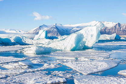
Part 5. Arctic Ocean route connecting Asia and Europe! ?
Ever since its launch in May 2012. the observation satellite Shizuku has attracted attention.
In August 2012, the sea ice covering the Arctic Ocean was observed to shrink at the fastest pace ever. In the past, the Arctic sea ice had recorded the smallest area on September 24, 2007 at 4.254 million square kilometers. In the summer of 2012, the pace continued much as in 2007, but it accelerated in August, when normally the pace slows down, bringing it to about 421 square kilometers, recorded as of August 24.
Much of the surface was covered with thin ice of less than one year since its formation, and the proportion of sea ice in a certain area was low, making it extremely brittle compared to the same period in the past.
The Arctic Ocean route is one of the shortest routes connecting Europe and East Asia. However, since the service route is determined by the condition of sea ice, the Arctic sea route between Asia and Europe depends on the condition of sea ice in the Arctic Ocean. Attention is being paid to the operating companies that pass.
Sea ice continues to thaw, and Shizuku is observing this phenomena very carefully.
Part 6. Quick, real-time, and near the user!
So as to provide information on the "current state of the earth" observed from space to users as soon as possible, networks on the earth are being used.
There are two types of routes. One is the "standard" route. The global observation data is stored in the Shizuku data record, and received at Svalbard in the Arctic Circle. After processing it at the Tsukuba Space Center, it will be provided to users and researchers.
The other is the “near real-time” route. When Shizuku flies around Japan, data is received in real time at Katsuura station or Tsukuba station. It will be sent to the Tsukuba Space Center to perform necessary processing automatically and will be provided to the Meteorological Agency and fisheries-related organizations in the future.
It is a rapid work done in minutes from observation to data arrival at the user's side. Since the optimum water temperature varies depending on the type of fish, if water temperature information is obtained, it will be possible to go straight to the fishing grounds of skipjack, swordfish or whatever, more efficiently.