Global Site
Breadcrumb navigation
Predicting when dust storms are coming by tracking airborne particles from space
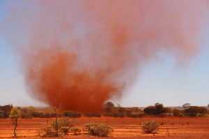
In early spring, dense clouds of sand and dust are whipped up by strong winds in the desert regions of East Asia and carried as far as Japan. The particles pick up pollutants on their journey through the air. This dense cloud, which soils washing and aggravates hay fever symptoms, is known as yellow dust.
The largest yellow dust particles measure 0.01 millimeters, and the smallest are just 0.000001 millimeters. Yet despite their minuscule size, SHIKISAI can still observe them from space. A suspension of fine particles dispersed in air, such as yellow dust, is termed an aerosol. When soil-derived aerosols like yellow dust travel through the air in large quantities, they absorb the shorter wavelengths. SHIKISAI exploits that property to observe them.
The Japan Meteorological Agency, in its daily weather forecasts, provides updates on the amount of yellow dust in the air. Since 2020 it has, by using satellite observation data, obtained more detailed information showing the exact route followed by yellow dust storms on their journey from the Asian continent. Currently it primarily uses data from the meteorological satellite HIMAWARI, but in future it will also harness data from SHIKISAI. NEC has been involved in the data processing of optical sensor capable of multi-channel observation (SGLI- Second Generation GLobal Imager) mounted on SHIKISAI, including measuring the optical thickness of aerosol, calibration and validation of SGLI observation data to verify the accuracy of 29 types of products.

Image showing yellow sand observed by SHIKISAI on March 29, 2018. The yellow arrow shows the band of aerosol (fine dust in the air) crossing from the Korean peninsula to the Japanese archipelago. Yellow sand is deduced from the wavelength of absorbed light.
©JAXA
Interview and article by Ayano Akiyama
Published March 30, 2020